High-Performance GPS system: unmatched productivity with reliable accuracy, from OnPOZ & Juniper Systems.
ScoutPak™ provides continuous GPS mapping under forests deepest areas.
ScoutPak™ is the best GPS solution on the market in terms of signal tracking under canopy and accuracy. ScoutPak™ is the result of mobile design innovations, data acquisition technologies, and OnPOZ's relentless drive to build high quality and high-performance products around their clients needs.

ScoutPak™ top ten features
|
| 01. |
Unmatched tracking capability, allows you to boost productivity without compromising data quality |
| 02. |
Unparalleled signal tracking for non-stop GPS mapping even under dense canopy |
| 03. |
Accurately tracks non-stop, no matter the canopy (distinctive accuracy at USDA Forest Service tests sites) |
| 04. |
Small and rugged design operates in the harshest environment |
| 05. |
No need for expensive and sophisticated antenna; it works with a patch antenna |
| 06. |
Long battery life guarantees operation for a full field day: summer or winter |
| 07. |
Combines a GPS/GIS professional field software with a powerful GIS viewer |
| 08. |
Efficient GIS plan view that displays multiple raster and vector maps all at once |
| 09. |
Get more out of your investment: Windows Mobile device, easy to pack and great for other applications |
| 10. |
Automatic and highly efficient post-processing capability at the touch of button to produce remarkable GPS data quality |
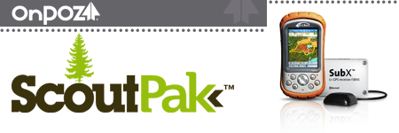
ScoutPak™ - Forestry Package - designed for tracking under dense canopy
ScoutPAK Brochure.pdf
Includes Archer Rugged Field PC, SubX GPS receiver and EZTag Geospatial data acquisition software.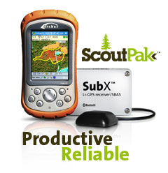
1) Archer Field PC
Ultra-Rugged PDA (64/256, Bluetooth) from Juniper Systems Inc
Windows mobile, bluetooth
Long battery life, up to 15 hours
2) SubX™
GPS Receiver from OnPOZ Precision Positioning
High performance GPS receiver
Fast re-aquisition time and tracking sensitivity
Low power consumption, up to 20 hours
SubX Datasheet.pdf
3) EZTag CE™
Geospatial Data Acquisition from OnPOZ Precision Positioning
Full function professional field data collection software
Multiple background maps
Adaptive navigation tools
Import/export to most GIS databases
EZTagCE Datasheet.pdf
Last updated: